Hiking matters #335: Successful ascent of Mt. Ragang

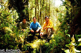
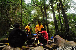
On April 4, 2013, 1205H, I together with Reynaldo Nalda, Lance Dy, reached the summit of Mt. Ragang together with our esteemed local guides. It was a very challenging trek, meriting a Difficulty 9/9 classification, and the logistics and security concerns involved a lot of effort, patience, and faith.
Mt. Ragang, also known as the Blue Mountain, is one of several high peaks of the Piapayungan Range, and many of these peaks have unverified altitudes. It will take further explorations of the range to confirm the relative elevations of these peaks, but I am convinced that what we reached is one of two highest peaks in the range, the other being Mt. Piapayungan, which has an aerial distance of 3.7 kms from the peak of Mt. Ragang.
The exploration climb lasted from April 1-5, 2013 and it took us 20 hours of hiking to reach the summit, and 17 hours to descend. The trail is highly overgrown and full ofrattan and lipa, owing to illegal logging in the mountain range during the 1990s. Beyond 2000 MASL, however, a beautiful mossy forest emerges, and even the peak is covered by a mossy forest.
LOCATION
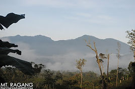
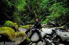
The banks of a beautiful river in a valley where wild deer live served as our campsite before assaulting the summit. Where mossy forests do not obscure the view, you can see the vast Lake Lanao, along with the towns of Maguindanao, Lanao del Sur, and Cotabato, the three provinces on whose borders the mountain range lies.
thank our Christian and Muslim brothers and sisters, as well as my companions in the trek, for making this hike possible. I see promise in the Piapayungan Range in terms of future explorations, and I will do my best to share information about this hike in the future, in coordination with local officials.
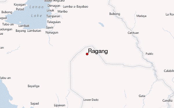
Location of Mount Ragang in the Philippines
Elevation
2,815 m (9,236 ft)[1]
Prominence
1,590 m (5,220 ft)[2]
Listing
Ultra
Location
Mindanao, Philippines
Coordinates
7°41′40″N 124°30′27″E
Geology
Type
Stratovolcano
Last eruption
January to April 1873
In the world of renewables, most of the attention is on the wind and the sun. Geothermal power just hasn’t gotten the same respect. That could be changing, as both the Obama Administration and Silicon Valley are considering the heat under the ground as a potentially huge source of clean, domestic U.S. energy, but recent setbacks are calling into question how much geothermal can contribute. Given the potential benefits, we should be doubling our efforts to make geothermal a viable power source for the U.S.
Some background: All thermal power plants use the same basic process. A heat source (burning coal or gas, uranium, concentrated solar energy) is used to turn water into steam, and the energy released turns a turbine that produces electricity. What sets geothermal apart is that the steam comes directly from the ground. Water percolates down through cracks in the ground and is heated to the boiling point by hot rocks underground (in some cases coming back up as a geyser — think Old Faithful), and the resulting steam is drawn up via a well to a turbine.
This makes for, in principle, the ideal alternative energy source. Geothermal power releases virtually no CO2 or pollutants. Crucially, geothermal provides baseload power — wind and solar power are better suited as peaking technologies, as they are dependent on energy sources that wax and wane over the course of a day. Geothermal power is on 24 hours a day, 365 days a year (geothermal power plants can have utilization rates up to 98%). And from a national security angle, the promise of geothermal is obvious: There is no more domestic source of energy than the actual ground underneath us.
There’s one problem, though. There are only a few places in the U.S. where you can find shallow groundwater hot enough to get steam directly from the ground. Engineers and geologists are therefore looking at a new way to tap underground heat. Enhanced Geothermal Systems (EGS) make use of the fact that, if you drill deep enough, any bedrock in the world gets hot enough to boil water. Basically, EGS involves drilling a well into deep, hot, dry rock; drilling a second well nearby to the same depth; fracturing the rock between those two wells enough to allow water to pass between them; and then pumping water down the first well and allowing it to percolate through the hot fractured area to the second well, where it will come back to the surface as superheated steam. The potential for EGS in the U.S. is enormous. A 2006 MIT report concluded it could provide 100,000 MW of power by 2050.
PLEASE CLICK ON THE UPPER PART OF THIS MESSAGE, FOR MORE INFORMATION ABOUT HOW VOLCANO GIVE ENERGY TO SOCIETY.